Department of Archaeology
Latest on the 1999 excavations
Current: November 1999
The 1999 excavation WWW page
The following is the latest information about the 1999 excavations in Longstones field. Eventually, this site will include a variety of photographic images, drawings and video clips as well as the information already included here. This page will also be updated as the results of post-excavation analysis (such as radiocarbon dates) become available.The excavation took place to the south west of the henge monument and on the line of the 'Beckhampton Avenue' recorded by William Stukeley between 1719 and 1724. The location map shows the location of the excavations in relation to the other major Neolithic monuments in the area.
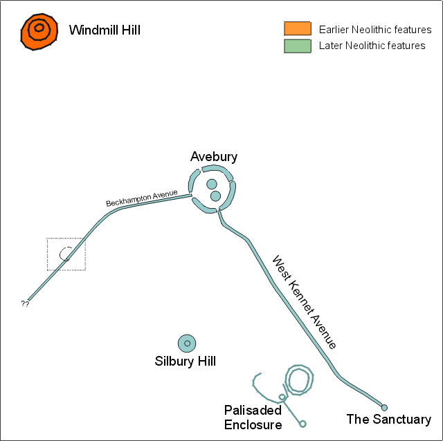
Schematic location map: showing the major earlier and later
Neolithic monuments (except long barrows).
Before we began the excavations, the field was believed to contain
a roughly oval ditch, revealed on an RCHM(E) air photograph in 1997. In
addition, several geophysical surveys have been undertaken in the field
by the Ancient Monuments Laboratory of English Heritage. These showed features
that could be interpreted as the remains of stones of the Beckhampton Avenue.
The main features of the site
The ditched enclosure
The ditch feature visible on the 1997 air photograph was identified and excavated in five trenches (10,11,12,13,14 and 15). In all cases it takes the form of a flat-bottomed ditch about 1 - 1.5m deep, apparently made up from short segments of ditch or elongated pits. Although nothing now survives of the bank, the asymmetry of the ditch fills suggests that the bank may have been placed on the interior of the enclosed area.
One of the apparent terminals of the ditch was also excavated (trench 14) demonstrating that the enclosure had at least one interruption. The ditch feature was not identified in the larger area (trench 10) suggesting that this interruption may be approximately 80m. Although the western part of the ditch is not visible on the air photograph, and may contain other interruptions, one possible interpretation is that the ditch forms a substantial 'C'-shaped enclosure with a single large entrance. If this is the case, then the location of the interruption is particularly interesting as it coincides with the location of the Beckhampton Avenue.
Four sections of ditch were excavated (trench 11, 12, 13 and 15), including the northern terminal (trench 15). In each case, the sequence of fills was similar. The ditch appears to have silted naturally until an intermittent turf line formed which (by comparision with experimental earthwork data) may represent only a few tens of years.
The uniformity of the upper fill of the ditch above this horizon suggests that it may have been deliberately backfilled. Although some sections of ditch did have areas of turf, in no case was this a continuous turf line across the whole feature, and this may have been formed from turves that have fallen from the old land surface as the ditch weathered.
The excavated ditch sections excavated contained very few finds. From the primary fill, only a single sherd of pottery was recovered, provisionally interpreted as Windmill Hill (earlier Neolithic) type. During excavation of the terminal, however, four items of animal bone were recovered from the base. These include a small articulated group of tarsals (toe bones), a vertebra and a small scapula. These should provide sufficient material for one or more radiocarbon dates for the constuction of the ditch.
The intermittent turf line of the ditch, identified in all the
cuttings, also produced animal bone finds (including horn core) that should
provide a date close to the backfilling event. At this horizon in one of
the cuttings we also located about half of a vessel, provisionally identified
as Grooved ware (see photographs of Grooved ware vessel in situ).
The Beckhampton Avenue
The larger excavated area revealed six features whose regular spacing and position strongly suggested that they were the remains of six stones of the Beckhampton Avenue recorded by Stukely in the 1720s. By analogy with the other parts of the Avebury monument, the erection of the stones probably date to the later Neolithic or earlier Bronze Age period (somewhere between 2500BC and 1800BC). Of the six features, three proved to be buried sarsen stones, two to be burning pits and the last a pit from which the stone had been removed.By analogy with the findings of Keiller during his excavations at Avebury and the West Kennet avenue, the three buried stones probably represent megaliths that were toppled and buried during 13th or 14th centuries. All three megaliths were substantial (probably weighing between 4 and 6 tonnes) although nowhere near the size of the two surviving stones in Longstones field. Two of the stones were found immediately beneath the subsoil, while the third was buried 50 or 60cm deeper.
The deepest of these buried stones proved to have two natural perforations, one large enough to pass an arm through. The second of these perforations was found to contain a split cattle bone and some fresh flakes, possibly representing a prehistoric deposit into the stone either at the time the stone was erected, or during the time it was standing. We intend to obtain a radiocarbon date for this bone.
Two of the features proved to be burning pits. These contain the last remnants of stones that had been destroyed during the later period of monument destruction (mid 17th to early 19th century). Features almost identical to these were also excavated by Keiller and a stone burning of this type was also witnessed by William Stukeley in the 1720s. Finds from one of these features, including a substantially complete clay tobacco pipe, suggest that this feature at least may be earlier than this: perhaps mid 17th century rather than early 18th.
The last of the features proved to be a pit with neither broken sarsen or burning evident. This is interpreted as a pit from which a stone had been removed.
In addition, the larger trench has revealed traces of Medieval ridge and furrow that were visible and correctly interpreted on the AML geophysical survey. A coin find from the base of this may provide an indication of the date of this period of cultivation.
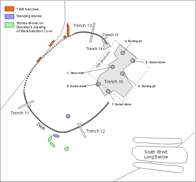
Plan of the excavations: showing the major features uncovered.
The ridge and furrow traces have been ommitted for clarity.
Images from the site
Lots of images, video clips and artwork is now available from the excavation of the Enclosure ditch and the Beckhampton Avenue, as well as some more general images of the site and the crew.Some of the wonderful drawings and paintings of the excavations by Jo Sumner are also now available online, although the reproduction on computer doesn't do them justice.